
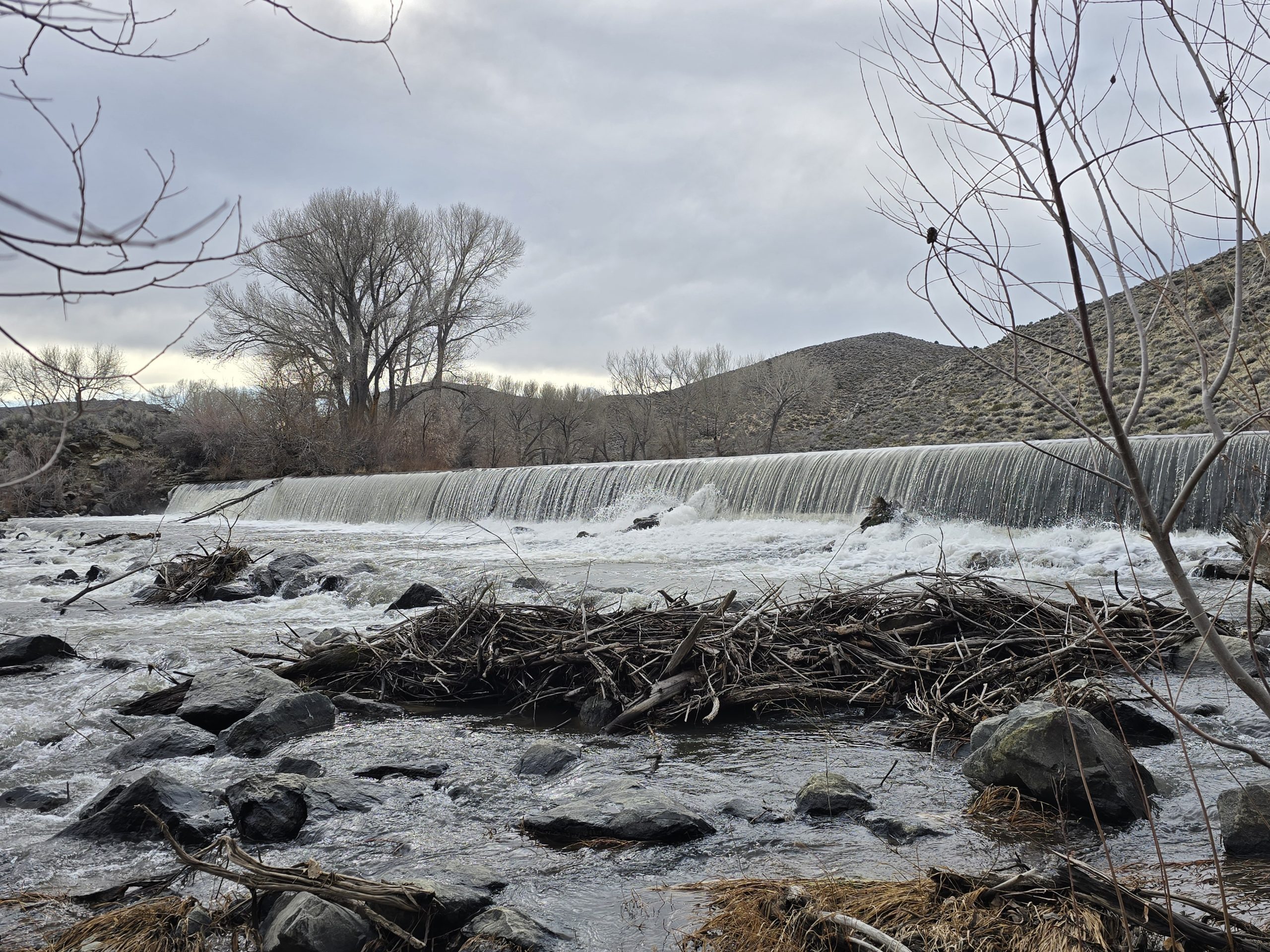
‘Tis the season for waterfalls in the Sierra. This hike quickly and unexpectedly went from great to incredibly memorable.
When my husband discovered this trail with a waterfall, we didn’t really know what to expect, but we figured it at least wouldn’t be snow-covered. Truth be told, you can park along California Hwy 49 and walk a short distance to see the “big show,” but where’s the fun in that?
Instead, my husband mapped a roughly 5-mile loop route that would result in the falls being our destination near the end. Perfect. And when we finished, we’d planned on surveying the forest road that leads to the trailhead for Haskell Peak to gauge whether or not we could make it in the Jeep and then hike up to the peak – we’d even brought snowshoes with us just in case. Then we’d also work in a lunch/dinner in Downieville before heading back to Tahoe.
Well, 1 outta 3 ain’t bad.
Here’s how it went: We hopped in the Jeep and headed northwest. The weather was beautiful. Sunny and blue skies, not too hot, but not too chilly – perfect for hiking. Once we arrived in the Sierra City area, we trepidatiously meandered through a small rural mountain cabin community until we reached the parking area off of the forest road. We ascended the rocky forest road for over a mile, passing through a mostly vacated campground and paralleling the flowing Haypress Creek. Lots of lovely little cascades along the way.

The rest of the hike was via the Pacific Crest Trail (PCT), which is normally a popular, heavily traveled trail system that is well-kept, but with it being so early in the season, we came across several downed trees across the trail. This one was the most notable obstacle that required some off-trail navigation to get around it.


About 2 miles from our starting point, we came upon this oddly sturdy bridge spanning Haypress Creek. So, not only did this hike have waterfalls, but it also had bridges!


Haypress Creek.

After we wound our way through the wooded area dotted with yellow and purple wildflowers, everything opened up to these amazing views of the prominent Sierra Buttes, one of our favorite hikes in the area.
Also, this tree is growing straight out of a rock.


The trail itself was very quiet and peaceful. In fact, until we arrived at Loves Falls, we only came upon two other hiking groups of two and one dog. Both groups were heading in the opposite direction as us and we chatted for a few minutes with the first pair as we passed them. Maybe 15 minutes later, we came cross the second pair of hikers, two guys named Jeff and Steve, making their way up the rocky switchbacks with trekking poles in hand.
I lost track of time, but we probably stopped and chatted with these guys for a good 15-20 minutes and we learned a lot about two strangers. Steve is originally from Chicago and Jeff from Colorado, but they now own a cabin in that small community we drove through to get to the parking area. They asked where we were from, but I think Midwest Steve already had an inkling after hearing our somewhat familiar accents.
We explained that we’d moved to Tahoe in 2013 after eloping at Sand Harbor and Steve’s ears perked up because attending a performance by the Classical Tahoe orchestra in our town is on his bucket list. They also informed us that Loves Falls was in prime form, so we were very excited to get there. At that, Jeff gave us some tips on how to best finish out our loop route beyond the falls, avoiding the need to walk along the rural highway. We thanked them and parted ways, continuing down the switchbacks.
Not long after, we got to this beautiful cascade cutting through the boulders and woods with a crystal-clear pool gathered where the trail intersects the falls. Simply amazing.


Several sections of the trail were rocky and I loved this section with its soft ground and tree canopy.

We also spotted a pine cone that looked different than any other we’ve seen. The little “fringes” really made it quite distinct. We had no idea what tree it came from, but we saw them frequently along this hike. (Spoiler Alert: I’ve since looked it up and it comes from a Douglas Fir tree.)

Soon, we began an abrupt descent as we approached Loves Falls. We
could hear it roaring in the distance.

Views from this amazing bridge.


We stopped for a few minutes here to have some snacks and watch the ants marching along the far side of the walking surface of the bridge. I’m not kidding. There were thousands of ants, all on an organized mission, walking swiftly in a line, traveling from one end of the bridge to the other.
Then we continued on our way, looking for the landmarks that Jeff had described. As we approached the little rural community of cabins again, I said to my husband, “Wouldn’t it be hilarious if we ran into Steve and Jeff again, like, sitting on a deck of one of these cabins?”
Just then, we saw them walking toward the cabins in the distance. I waved my arm in an exaggerated fashion and made my way closer to them. This reunion was soon followed by an invitation to sit outside at their cabin for bubbly water and snacks. We obliged. (Their cats welcomed us, too.)
Again, I lost track of time, but we probably sat and visited with them for two hours, sharing favorite hikes, mountain bike trails, and local restaurants, along with an exchange of bear stories. We learned that they were both retired and enjoying the slower, quieter pace at their cabin of three years. All of the cabins surrounding them are owned by members of the same family, so they felt fortunate to be outsiders accepted into the “neighborhood.” And we felt fortunate to have experienced this serendipitous hiking adventure.
Needless to say, we neither made it on our second planned hike for the day, nor did we make it to Downieville for dinner. 🤣 Perhaps another day.
Once we left their cabin, we walked about a mile back to our Jeep in the parking area and chuckled about how the day had unfolded. The scenic trail and waterfalls exceeded our expectations and the unexpected visit with new friends was the icing on the cake.
On our drive back to Tahoe, we were on the section of Hwy 49 that is bookmarked by large signs warning of “dead man’s curves” for the next 15 miles. In case our day needed more unexpected events, I spotted a mini-van on its side over the edge of the highway.

Unsure whether this was a recent incident, we found a safe place to turn around and drive back to the accident to confirm nobody needed help. Seeing the spray-painted dots on the tires confirmed it had already been taken care of, and relieved, we continued on our way back to Tahoe as the sun began to set in the Sierra sky.
Most hikes are memorable, but this one will surely stand out for years to come.

| Loves Falls loop | |
|---|---|
| Total Distance | 4.66 mi |
| Total Time | 2:28:57 |
| Total Ascent | 843 ft |
| Max Elevation | 4,884 ft |
Leave a Reply